Coastal Storm Impacts
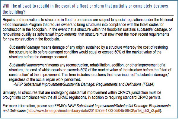
7. How will coastal storms and flooding affect the property and structures? Will I be allowed to rebuild in the event of a flood or storm that partially or completely destroys the building?
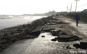
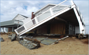
In Rhode Island, tidal flooding, high winds, coastal flood events, hurricanes and other storms can impact property and activity along the shoreline. Severe weather and associated inundation can cause extensive and expensive damage to coastal properties, and, in extreme cases, may debilitate entire communities.
Storms & Flooding
Storms are a year-round concern for coastal residents, as tropical storms and hurricanes occur in late summer and early fall while extratropical storms, including nor’easters, occur in mid- to late-fall, winter, and early to mid-spring.
Storms cause coastal erosion and other shoreline changes due to high winds, increased ocean water height, and wave action along the coast. Several factors contribute to a storm’s magnitude and destructive power, including wind speed, wind direction, wave action, and the status of the tide at the time of the storm’s passing.
The storm surge, which is an elevation of water beyond the typical tidal range that occurs during storms, can result in flooding when storm winds push the elevated ocean water toward the coastline. The storm surge combined with the normal tidal elevation is the storm tide, or the observed level of the ocean during a storm event. The storm surge can cause extensive damage to coastal property and is a serious hazard during coastal storms and hurricanes.
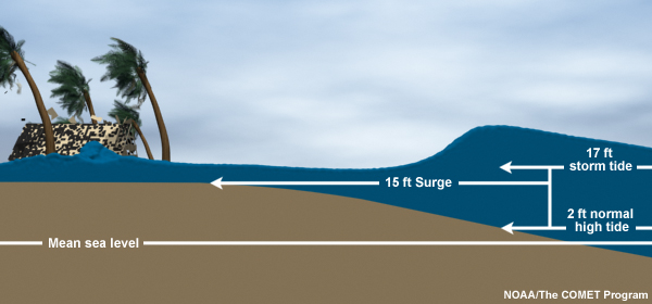
During a storm event like a hurricane, a storm surge forms on top of normal tide levels. The resulting storm tide can cause extensive coastal inundation if winds push the ocean water toward the shoreline. Image source: www.nhc.noaa.gov/surge/
As a result of climate change, future storm events may produce stronger wave action, larger storm surges, and extreme precipitation, resulting in greater flood impacts and increased coastal erosion. Moreover, climate change is anticipated to cause increased frequency and intensity of storms.
Review the Rhode Island Hurricane Inundation Maps and Rhode Island STORMTOOLS interactive map to see how flooding caused by coastal storms and hurricanes may impact the property and the nearby area. Even if the property isn’t in a flood zone, flooding in the surrounding area may damage critical infrastructure or make evacuation routes inaccessible.
Rhode Island’s Big One – The 1938 Hurricane
Similarly to the way in which flood zones are defined by likelihood of a flood event’s occurrence, storms are categorized by magnitude and probability of occurrence during a given time period. A ‘100-year storm event’ has about a 1 in 100 probability of occurring during any given year. The Hurricane of 1938 meets the storm surge and wave height criteria for a 100-year storm, and as such is the “storm of record” for Rhode Island.
The 1938 Hurricane was devastating for Rhode Island as a whole, and was especially destructive for coastal communities along the south shore of the state. The hurricane was particularly impactful because forecasters expected the storm to move away from the New England coast, and coastal residents were not adequately warned about the impending disaster.
Though Sandy caused destruction due to high winds and flooding, the storm was not a worst-case scenario for R.I. In comparison, the 1938 Hurricane was far more damaging. For photos from the 1938 Hurricane, please visit the Providence Journal’s photo gallery.
![]()
THE 1938 HURRICANE AND HURRICANE SANDY – The 1938 event was a Category 3 Hurricane that coincided with a high tide, and passed just to the west of Rhode Island, causing the region to experience wind speeds of the hurricane’s highest velocity. In contrast, Hurricane Sandy did not hit the state directly, and was technically a Post-tropical Cyclone when it impacted Rhode Island.
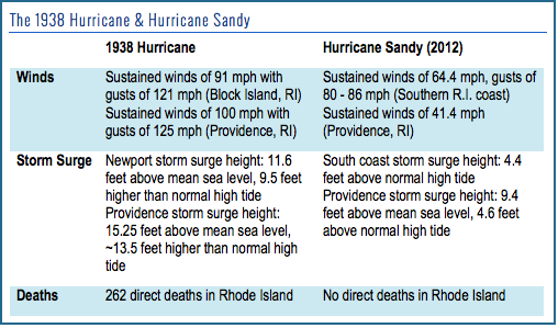
While Sandy caused significant damages in Rhode Island, the 1938 Hurricane eclipses the 2012 event in wind speed, height of storm surge, and overall strength. Furthermore, coastal development has reclaimed much of the land area impacted by the ’38 storm, so even more property, assets, and infrastructure will be at risk should a 100-year-storm hit Rhode Island directly.
Sources: ‘The Great New England Hurricane of 1938’, NOAA National Weather Service (www.erh.noaa.gov/box/hurricane/hurricane1938.shtml), ‘Hurricane of ’38 wrought unparalleled destruction, death on unprepared R.I.’, Providence Journal (www.providencejournal.com/breaking-news/content/20130920-hurricane-of-38-wrought-unparalleled-destruction-death-on-unprepared-r.i..ece), ‘Examining The Impacts of Hurricane Sandy on Rhode Island: A serious wake-up call’ David R. Vallee (www.slideshare.net/riseagrant/examining-the-impacts-of-hurricane-sandy-on-rhode-island-a-serious-wakeup-call), and ‘Tropical Cyclone Report – Hurricane Sandy’, NOAA National Weather Service (www.nhc.noaa.gov/data/tcr/AL182012_Sandy.pdf).
Hazard Preparedness & Hurricane Evacuation
A storm of the magnitude experienced in 1938 has about a 1 in 100 probability of occurring in a given year, meaning that there is a 30% chance that a coastal structure will be impacted by at least one major storm event over the course of a 30-year mortgage. However, there is always a risk that a significant storm or flooding event will occur, and coastal residents especially should be prepared for a large-scale event.
HAVE A DISASTER PLAN – The R.I. Emergency Management Agency recommends that all Rhode Island residents prepare for disasters by reviewing evacuation zones and routes, instating evacuation plans, and having disaster supply kits (RIEMA Evacuation Information). Additionally, coastal residents should view the Rhode Island Hurricane Inundation Maps and the Rhode Island Hurricane Evacuation Maps in order to anticipate storm-surge related evacuations.
For information about planning for hurricanes and other hazards, consult your municipality’s hazard mitigation plan, the CRMC Hurricane Preparedness Guide, Storm Smart Rhode Island, and the 2014 R.I. Hazard Mitigation Plan.
KNOW YOUR RISK – Consult the flood zone maps, inundation maps, and wind zone map for Rhode Island to understand the property’s susceptibility to coastal storms. If there are existing buildings on the property, structures should be assessed by an inspector or engineer to discover how well they will withstand storm events. For more information about how a structure was built, and whether it has undergone any repairs in the aftermath of storms, owners or potential buyers can contact the municipality’s building official to view permitting records.
MINIMIZE YOUR RISK – Where possible, owners should retrofit or build structures to increase structural resiliency in the face of wind and flood loads. Elevating structures and setting structures back from the coast are recommended practices for minimizing risk. Remember: no method is 100% fail-safe when it comes to protecting coastal property from storm-related damage, but certain measure can lower the structure’s vulnerability to storms.
DURING THE STORM – In the event of severe coastal storms or a hurricane, heed the warnings of local or state officials, and evacuate the area if necessary. Personal safety should be the primary concern of residents during hazardous conditions.
AFTER THE STORM –Coastal structures can sustain damage from high winds, flooding, and storm-carried debris during a storm event. While homeowner’s insurance may cover wind damage, only flood insurance will cover damage caused by flooding. Review your policies to understand what damage will be covered, and to what extent. For more information about insurance and claims, see HURRICANE PREPARATION: Act Now to Make Filing a Claim Easier After the Storm.
NEXT: Assessing Risk for Existing Buildings >>
This website has been prepared by the University of Rhode Island’s Coastal Resources Center and Rhode Island Sea Grant for the R.I. Coastal Resources Management Council as a guidance resource. It is not intended nor should be used to give any legal advice nor to supersede any state or federal statutory or regulatory language or interpretation of such language. This website refers the reader to various regulations and policies adopted by federal and state regulatory agencies; the reader is encouraged to review the specific regulation and policy.
Rhode Island Coastal Property Guide Credits & Acknowledgements

