Featuring~Rhode Island e911 Exposure Assessment page
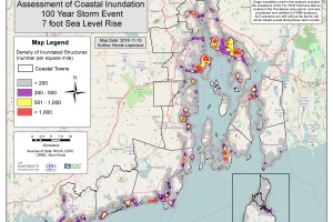
Take a look at the “e911” page, this page offers a summary of all exposed structures in each of the 21 coastal municipalities in Rhode Island within a variety of coastal flooding scenarios: (1) from twice-daily tides based on sea level rise projections to the year 2100; and, (2) from coastal storm events with and without sea level rise scenarios.